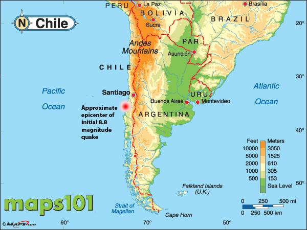
Chile (along with the other west coast South American countries) lies right on the edge of the South American Tectonic Plate, which is colliding with the Nazca Plate at a rate of 70mm each year. Add to that the Antarctic Plate smashing into southern Chile at 20mm per year, and it's not at all surprising that Chile experiences a lot more and often much bigger earthquakes than most other parts of the world.
 Southern Chile, as can be seen on the above map (from https://walrus.wr.usgs.gov/earthquakes/sopac.html) also lies on the junction of these three major tectonic plates mentioned above. This map shows the complex geology here:
 As recently as Christmas Day 2016, Chiloe Island was hit by a massive 7·6 Richter earthquake which although it caused damage, mercifully claimed no lives:

From (http://www.telegraph.co.uk/news/2016/12/25/tsunami-warning-aftermagnitude-77-earthquake-strikes-southern/).
On the 22nd May 1960, the most powerful earthquake ever recorded (source Wikipedia) struck Chile at a recorded strength of about 9·5 Richter. As well as significant local damage in Chile, a massive tsunami travelled around the Pacific with an 82 ft wave devastating the Chilean coast and locations as far away as New Zealand, Australia and Japan all suffering damage:
 (from https://infogr.am/the-great-chilean-earthquake)
and there's a particularly good animation of the spread of the tsunami here on youtube. Note the coastlines highlighted in red as the tsunami strikes, there are quite a lot of them.
In 2014 there were seven earthquakes of magnitude 7·0 or greater! So, it looks quite likely that while in Chile, we might experience an earthquake or two!
On the 22nd May 1960, the most powerful earthquake ever recorded (source Wikipedia) struck Chile at a recorded strength of about 9·5 Richter. As well as significant local damage in Chile, a massive tsunami travelled around the Pacific with an 82 ft wave devastating the Chilean coast and locations as far away as New Zealand, Australia and Japan all suffering damage:
and there's a particularly good animation of the spread of the tsunami here on youtube. Note the coastlines highlighted in red as the tsunami strikes, there are quite a lot of them.
In 2014 there were seven earthquakes of magnitude 7·0 or greater! So, it looks quite likely that while in Chile, we might experience an earthquake or two!
No comments:
Post a Comment